Thaddeus Kosciuszko National Memorial
Designation: National Memorial
Location: Pennsylvania
📘 Park Overview
Visit the house where wounded Polish freedom fighter Thaddeus Kosciuszko lived and hear how this brilliant military engineer designed successful fortifications during the American Revolution. See the room where he received notable visitors such as Chief Little Turtle and Thomas Jefferson.
🌤 Weather Information
Summers are typically hot and muggy, fall and spring are generally mild, and winter is cold. Snowfall is highly variable, with some winters bringing only light snow and others bringing several major snowstorms, with the normal seasonal snowfall standing at 22.4 in (57 cm). Precipitation is generally spread throughout the year, with eight to twelve wet days per month.
🚗 Directions
The Thaddeus Kosciuszko National Memorial is located at 301 Pine Street in Philadelphia. It is within walking distance of Independence Hall and the Liberty Bell Center. Parking is quite limited near the site. The site is easily accessible by public transportation. See the park's web page for directions.
Images

The Thaddeus Kosciuszko house is a national memorial to an international champion of human rights. Kosciuszko fought in the American Revolutionary War, as well as an uprising in his native Poland..
Credit: NPS Photo

Explore the exhibit area to learn about Polish military engineer Thaddeus Kosciuszko's role in designing fortifications at West Point.
Credit: NPS Photo

Wounded Polish freedom fighter Thaddeus Kosciuszko received notable visitors in this home, including Chief Little Turtle and Thomas Jefferson
Credit: NPS Photo
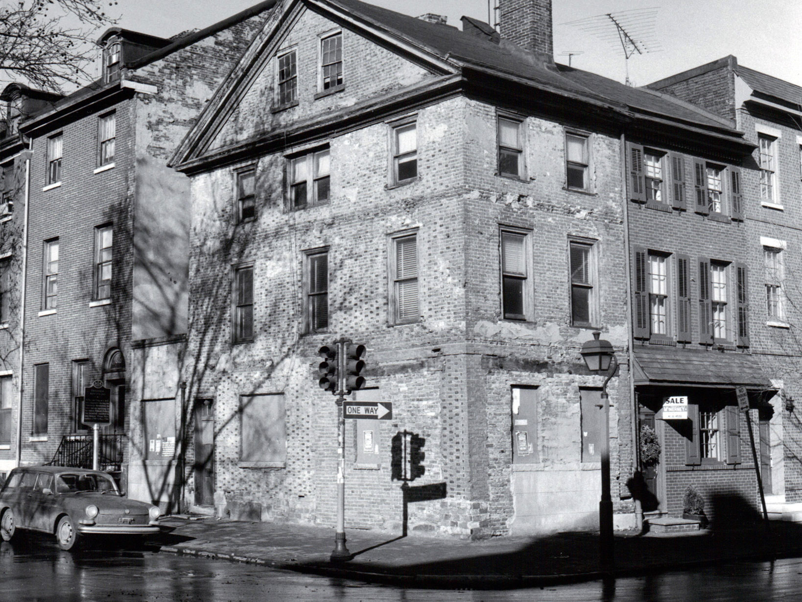
The home where Thaddeus Kosciuszko once lived fell into disrepair. The site became a National Memorial in 1972.
Credit: NPS Photo
Activities
Topics
Operating Hours
Entrance Fees
No entrance fees listed.
Entrance Passes
No entrance passes listed.
3-Day Weather Forecast
Friday, Dec 19

Heavy rain
High: 58.8°F | Low: 31.5°F
Humidity: 80%
Wind: 23 mph
Rain Chance: 89%
UV Index: 0.1
Sunrise: 07:18 AM
Sunset: 04:38 PM
Moon: New Moon (1%)
Visibility: 5 mi
Dew Point: 44.5°F
Cloud Cover: 89%
Pressure: N/A mb
Air Quality (PM2.5): N/A
Ozone: N/A
EPA Index: N/A
Saturday, Dec 20

Sunny
High: 35.8°F | Low: 24.1°F
Humidity: 72%
Wind: 15.9 mph
Rain Chance: 0%
UV Index: 0.3
Sunrise: 07:19 AM
Sunset: 04:38 PM
Moon: New Moon (0%)
Visibility: 6 mi
Dew Point: 26.1°F
Cloud Cover: 0%
Pressure: N/A mb
Air Quality (PM2.5): N/A
Ozone: N/A
EPA Index: N/A
Sunday, Dec 21

Partly Cloudy
High: 44.4°F | Low: 27.5°F
Humidity: 75%
Wind: 13.9 mph
Rain Chance: 0%
UV Index: 0.2
Sunrise: 07:19 AM
Sunset: 04:39 PM
Moon: Waxing Crescent (1%)
Visibility: 6 mi
Dew Point: 29.1°F
Cloud Cover: 0%
Pressure: N/A mb
Air Quality (PM2.5): N/A
Ozone: N/A
EPA Index: N/A
Weather Alerts (6)
Wind Advisory issued December 19 at 12:46PM EST until December 20 at 1:00AM EST by NWS Mount Holly NJ
Effective: Dec 19, 2025 12:46pm
Expires: Dec 20, 2025 1:00am
* WHAT...West winds 20 to 30 mph with gusts of 40 to 50 mph.
* WHERE...Portions of central and northern Delaware, northeast
Maryland, central, northern, northwest, and southern New Jersey,
and east central and southeast Pennsylvania.
* WHEN...Until 1 AM EST Saturday.
* IMPACTS...Gusty winds will blow around unsecured objects. Tree
limbs could be blown down and a few power outages may result.
* ADDITIONAL DETAILS...The strongest winds are expected to occur
during the second half of the afternoon into the early evening.
Severe Thunderstorm Warning issued December 19 at 2:51PM EST until December 19 at 3:45PM EST by NWS Mount Holly NJ
Effective: Dec 19, 2025 2:51pm
Expires: Dec 19, 2025 3:45pm
SVRPHI
The National Weather Service in Mount Holly NJ has issued a
* Severe Thunderstorm Warning for...
Ocean County in southern New Jersey...
Camden County in southern New Jersey...
Mercer County in central New Jersey...
Somerset County in northern New Jersey...
Northern Atlantic County in southern New Jersey...
Southeastern Hunterdon County in northwestern New Jersey...
Central Gloucester County in southern New Jersey...
Burlington County in southern New Jersey...
Monmouth County in central New Jersey...
Middlesex County in northern New Jersey...
East central Montgomery County in southeastern Pennsylvania...
Southeastern Bucks County in southeastern Pennsylvania...
Central Philadelphia County in southeastern Pennsylvania...
* Until 345 PM EST.
* At 251 PM EST, showers with damaging winds were located along a
line extending from near New Hope to Turnersville, moving east at
50 mph.
HAZARD...60 mph wind gusts.
SOURCE...Radar indicated.
IMPACT...Damage to roofs, siding, trees, and power lines is
possible.
* Locations impacted include...
Philadelphia, Toms River, Trenton, Camden, New Brunswick, Perth
Amboy, Long Branch, Asbury Park, Somerville, Gloucester City, Sandy
Hook, Somerset, Edison, Lakewood, Cherry Hill, Middletown, Old
Bridge, Bensalem, Jackson, and Howell.
Severe Thunderstorm Warning issued December 19 at 2:41PM EST until December 19 at 3:45PM EST by NWS Mount Holly NJ
Effective: Dec 19, 2025 2:41pm
Expires: Dec 19, 2025 3:45pm
SVRPHI
The National Weather Service in Mount Holly NJ has issued a
* Severe Thunderstorm Warning for...
Morris County in northern New Jersey...
Hunterdon County in northwestern New Jersey...
Sussex County in northwestern New Jersey...
Warren County in northwestern New Jersey...
Northern Somerset County in northern New Jersey...
East central Lehigh County in eastern Pennsylvania...
East central Carbon County in northeastern Pennsylvania...
Northwestern Bucks County in southeastern Pennsylvania...
Monroe County in northeastern Pennsylvania...
Northampton County in eastern Pennsylvania...
* Until 345 PM EST.
* At 241 PM EST, showers with damaging winds were located along a
line extending from near Blakeslee to near Quakertown, moving
northeast at 50 mph.
HAZARD...60 mph wind gusts.
SOURCE...Trained weather spotters.
IMPACT...Damage to roofs, siding, trees, and power lines is
possible.
* Locations impacted include...
Allentown, Easton, Morristown, Somerville, Newton, Montague, Mount
Pocono, Bethlehem, Bridgewater, Dover, Madison, Hopatcong, Forks,
Florham Park, East Hanover, Lincoln Park, Kinnelon, East
Stroudsburg, Hackettstown, and Quakertown.
Wind Advisory issued December 19 at 12:46PM EST until December 20 at 1:00AM EST by NWS Mount Holly NJ
Effective: Dec 19, 2025 12:46pm
Expires: Dec 20, 2025 1:00am
* WHAT...West winds 20 to 30 mph with gusts of 40 to 50 mph.
* WHERE...Portions of southern Delaware and central and southern New
Jersey.
* WHEN...Until 1 AM EST Saturday.
* IMPACTS...Gusty winds will blow around unsecured objects. Tree
limbs could be blown down and a few power outages may result.
* ADDITIONAL DETAILS...The strongest winds are expected to occur
during the second half of the afternoon into the early evening.
Flood Warning issued December 19 at 12:28PM EST until December 19 at 4:30PM EST by NWS Mount Holly NJ
Effective: Dec 19, 2025 12:28pm
Expires: Dec 19, 2025 4:30pm
* WHAT...Flooding caused by excessive rainfall and snowmelt is
expected.
* WHERE...A portion of northern New Jersey, including the following
county, Hunterdon.
* WHEN...Until 430 PM EST.
* IMPACTS...Flooding of rivers, creeks, streams, and other low-lying
and flood-prone locations is imminent or occurring.
* ADDITIONAL DETAILS...
- At 1221 PM EST, the USGS gauge on the Neshanic River at
Reaville had a stage of 6.63 ft. Minor flooding is known to
begin near the gauge at 6.50 ft. Roads are subject to
closures. Between 1.5 and 2 inches of rain have fallen since
last night. In addition, snowmelt has added to the excessive
runoff.
- For Neshanic at Reaville:
At 12:00pm the stage was 6.63 feet.
Flood Stage is 6.5 feet.
- http://www.weather.gov/safety/flood
Severe Thunderstorm Warning issued December 19 at 3:14PM EST until December 19 at 3:45PM EST by NWS Mount Holly NJ
Effective: Dec 19, 2025 3:14pm
Expires: Dec 19, 2025 3:45pm
At 314 PM EST, severe thunderstorms were located along a line
extending from near Greeley to Bridgewater, moving northeast at 60
mph.
HAZARD...60 mph wind gusts.
SOURCE...Trained weather spotters.
IMPACT...Damage to roofs, siding, trees, and power lines is
possible.
Locations impacted include...
Morristown, Somerville, Newton, Montague, Bridgewater, Dover,
Madison, Hopatcong, Florham Park, East Hanover, Lincoln Park,
Kinnelon, East Stroudsburg, Hackettstown, Chatham, Boonton, Butler,
Wharton, Washington, and Rockaway.
Park Alerts
Visitor Center & Contacts
📍 Physical Address:
3rd and Pine Streets
Philadelphia, PA 19106
🏤 Mailing Address:
c/o Independence National Historical Park
143 S. 3rd Street
Philadelphia, PA 19106
📞 Voice Phone: 2159652305
✉️ Email: indevisitorinfo@nps.gov